
 Science
More accurate forecasts of dangerous tsunamis and powerful earthquakes can be made in the near future, allowing millions of people living in vulnerable areas of the western United States to sleep peacefully, reported scientists at the annual meeting of the American Seismological Society.
The tools that scientists need for such accurate forecasts already exist: to do this, it is necessary to add GPS data to the information already available to seismologists, obtained from seismometers.
“Seismometers can provide some predictions, but the information they provide is limited, especially when it comes to large earthquakes,” said Yehuda Bock. surveyor from the Scripps Oceanographic Institute in La Yolla, California. Bock stressed that the 2011 earthquake in Japan and the devastating tsunami that followed it once again make it clear that we should look for ways to more accurately predict such events.
Although Japan has very advanced technologies for predicting earthquakes and tsunamis, they do not use GPS data, which provides key information about the actual magnitude of the most powerful earthquakes.
Combining data
Seismometers close to the quake's epicenter can pay attention to the energy that is being released and transmit real-time information to remote locations, making it possible to predict when tremors will reach settlements. However, seismometers are not very accurate in predicting earthquakes of magnitude 7 or higher, that is, the worst earthquakes. GPS comes to the rescue. Although it takes a little longer for information to arrive from the Global Positioning System, GPS is very good at capturing magnitude because it literally measures Earth's vibrations surfaces.
“We're talking about a few centimetres of accuracy,” the researchers said.
When the 2011 earthquake in Japan hit the open sea along the subduction zone (a place where the ocean floor slowly goes under the tectonic plate), it was reported that it had reached power 8 points within 120 seconds. An 8 magnitude earthquake is a very powerful earthquake, but it was not expected to cause a tsunami of this magnitude. When researchers looked at the GPS data, it was clear that the quake actually had a magnitude of 9, 30 times stronger than previously thought.
A double threat
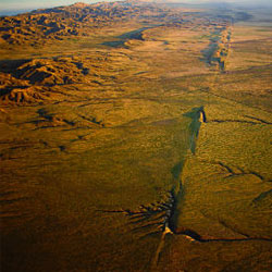
The seismological situation in the US is slightly more complicated than in Japan. The Japanese are most concerned about earthquakes that occur in the ocean. Americans are threatened not only from the sea along the Cascadia subduction zone, which is located along the east coast of the United States, but also from land where earthquakes may occur due to horizontal displacement in San Andreas Fault (pictured).
The earthquake warning system currently uses both GPS and seismometers, with about 50 scientists and several public and private institutions having access to this information. This system requires additional tools that will make it possible to deliver information to the public. Such tools will be developed by 2015 if they receive appropriate funding. According to today's estimates, this requires about $150 million.
The system will be able to alert people for a few seconds or minutes before an earthquake occurs. When a person gets into an earthquake wave, he feels the Earth's surface vibrations, but the epicenter of the earthquake may be far from him, an earthquake can actually occur at a few seconds or minutes early.