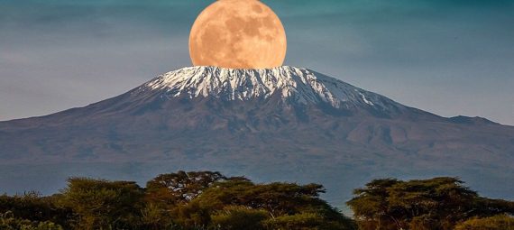
The “crown of Tanzania” is Mount Kilimanjaro (from Swahili — “the mountain that sparkles”). It is impossible not to recognize it — towering right above the flat plains, covered with a snow cap at the top, it has become a real symbol of the country. Every year about 15 thousand people “storm” Kilimanjaro and only 40% reach the top.
Kilimanjaro is the highest mountain in Africa (5890 m), the diameter of its base is 60 km.
For those who feel that they may not have enough patience for a full—fledged ascent, the nearby Serengeti National Park, one of the largest nature reserves in the world, is ready to open its beauties. Another oasis of African colorful nature is Tarangire National Park, located on the banks of the Tarangire River flowing from north to south.
Weather in Kilimanjaro
Kilimanjaro has a distinct rainy season. The air temperature can change dramatically depending on the altitude, as well as on the time of day. For example, in the lower plains at the foot of Kilimanjaro, the average temperature is +30 ° C, at an altitude of 3000 m — freezing and +5…15 °C. At night, the temperature at the top drops below zero.
Climbing Kilimanjaro can be done throughout the year, but it is believed that the best time is from August to October and from January to March.
An amazing feature is that the ascent to Kilimanjaro is accompanied by all types of climate on our planet, starting from the humid tropics and ending with chilling snow peaks.
To visit the Kilimanjaro National Reserve, you need to find a travel agency accredited in the Kilimanjaro National Park in the nearest town of Moshi and buy a tour from them for about $ 1,000. Professional guides, porters (porters) and even cooks are ready to accompany you on this adventure, the duration of which usually lasts 5-6 days. The best period for climbing is from December to February or from June to October.
The reward waiting for you at the top of the mountain will pay off all your hiking efforts. First, you will see the unique eternal ice (Kilimanjaro is located three degrees south of the equator). Secondly, it is possible to contemplate within the inner Crater Reusch (1.3 km in diameter) signs of volcanic activity, including smoke and the smell of sulfur. Thirdly, if you look down from the top, you can see 7 well-defined trails, along which ascents to the peak of the world natural attraction are carried out.
Five of these trails are intended only for climbing (that is, you can only go up on them, but descending from the top on these trails is prohibited by the rules of the Kilimanjaro National Park). Another Mweka trail (Mweka) serves only for descent. And another Marangu trail (Marangu, or “Coca-Cola way”) serves both for climbing and descending. All these trails at an altitude of 4 km are crossed by a circular trail — this is the Kibo Ring, divided into the Northern Kibo Ring and the Southern Kibo Ring.
Three trails from the ring road lead to the Kibo Peak crater caldera: the Western Break Trail (also known as the Glacier Arrow Route), the Barafu Trail and an unnamed third trail leading from Kibo Hut to Gilmanda Point (from where you can look into Kibo Crater).
Approximate prices for organized tours:
- Group 4-5 people — 3600 USD/person.
- Group 6-7 people — 3450 USD/person.
- Group of 8 people and above — 3300 USD/person.
The highest point is Uhuru peak of Kibo volcano (5,895 m), belonging to the “Seven Peaks” (five thousand meters). The peak was first conquered by Hans Mayer in 1889. The other two peaks are the extinct Mawenzi volcanoes in the east (5,149 m, the third highest in Africa) and to the west of the main mountain lies Shira (3,962 m), the oldest of all volcanoes.
Climbing Mawenzi requires climbing skills on rocks, snow and ice. But the ascent to the higher Uhuru peak is considered quite simple, although it takes time for acclimatization. The three easiest routes – Marangu, Rongai and Mashame — can be climbed by almost anyone without mountaineering training. Other routes, such as the “Polish glacier” and the “western gap”, require special equipment.
There are six main climbing routes leading to the foot of Kibo Peak:
- the little-used Shira route (Shira),
- Lemosho route (Lemosho),
- Mashame route (Machame),
- Umbwe route (Umbwe),
- Marangu route, or “Coca-Cola Way” (Marangu) and
- the northern Rongai or Loitokitok route (Loitokitok omron).
Which path to choose depends on your initial choice of route. If you climb the more difficult and interesting trail “Glacier Arrow Route”, you need to start climbing along the routes of Shiva, Lemosho, Mashame and Umbwe. If an easier way from Kibo Hut is preferable, then it is worth choosing the Marangu (Coca-Cola) or Rongai route. You can also create your own author’s route, but for this you will have to take permission in advance from the park administration (KINAPA). Get ready for additional costs and paperwork.